Balancing ecology and drainage capacity
Optimise mowing and maintenance operations with data science
The Dutch water authority Aa en Maas engaged Royal HaskoningDHV Digital to help it better understand the relationship between watercourse discharge capacity and local vegetation levels, so it could optimise its mowing operations.
Through intensive discussions with hydrologists, maintenance teams and other domain experts, we developed a data science model that shows the drainage gradient of a defined section of watercourse. This model now demonstrates the impact of mowing sessions, enabling the water authority to better plan where and when to mow.
Through intensive discussions with hydrologists, maintenance teams and other domain experts, we developed a data science model that shows the drainage gradient of a defined section of watercourse. This model now demonstrates the impact of mowing sessions, enabling the water authority to better plan where and when to mow.
Project facts
- ClientWaterschap Aa en Maas
- Date2019-2020
- ChallengeOptimising mowing operations across thousands of kilometres of watercourse to ensure that rivers can drain effectively, without impacting local ecology objectives. Lisette van Beusekom
- SolutionWe developed a data science model that visualises the relationship between water levels, flow rates, weather data, geological data and time characteristics to clearly show how mowing impacts drainage gradients, and where mowing is most needed.
Results
Supported ecology protection objectives
Helped optimise mowing and maintenance operations
The challenge
Meeting drainage and ecology objectives
The Dutch water authority Waterschap Aa en Maas is responsible for maintaining thousands of kilometres of watercourse around the Aa and Maas rivers, ensuring that drainage capacity remains high, and local ecology is protected.
Balancing these often conflicting goals can be extremely challenging. Watercourse could be mowed frequently, keeping drainage high, but over mowing can cause significant ecological damage and impact river wildlife and vegetation.
To balance their objectives, the water authority wanted to find a better way of understanding exactly where and when mowing was needed, using detailed data and modelling drainage gradients across the watercourse.
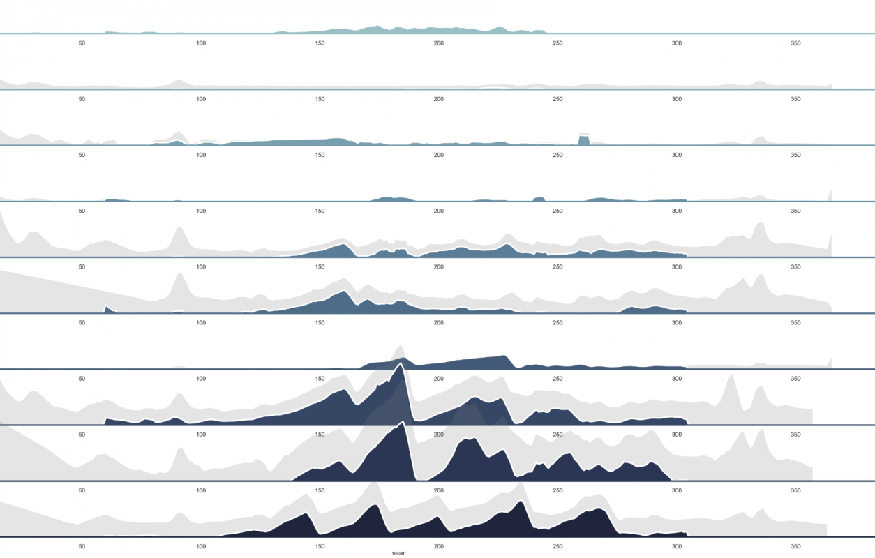
Above you see a visualisation of total water level difference (light gray) and water level difference by vegetation (dark blue) in 2015 on a route with 10 dams (from top to bottom). The influence of vegetation and mowing is increasingly visible further upstream.
The solution
Machine learning and hydrological knowledge combined
Aa en Maas engaged Royal HaskoningDHV Digital to help it develop a data science model that could clearly show where drainage capacity is being significantly impacted by vegetation and other environmental factors.
Working closely with hydrologists, management and maintenance experts, policy staff, ecologists and area managers, we mapped out all the available data, and began devising a new way to process and visualise it all together.
Together with the water authority’s data lab, we developed a proof of concept model capable of estimating the current gradient caused by vegetation by looking at water levels, flow rates, weather data, geological data, time characteristics and other data sources.
The result
Bringing balance to the region
With our co-created model in place, Aa en Maas can now clearly see the impact that vegetation is having on drainage levels across the river. This enables the authority to visualise the impact of mowing sessions in the summer, and optimise mowing activities.Now, with a reliable data model, the authority can better understand where mowing is truly needed, and avoid unnecessary disruption to local ecology – bringing it one step closer to achieving its complex and conflicting drainage and ecology goals.
Related projects
Anything we can help with?
Have a question, comment or business enquiry? Talk to one of our experts to see how we can help.